Any day that’s too windy for the lake or golf courses, here’s an idea from your Katepwa Nature Trails Committee of Rick Vigrass, Don Howden, Beve Gardner and Dan Farthing. In addition to the TransCanada Trail, come and travel on three other trails near the lake, see Map of Katepwa Non-TransCanada-Trail Trails. They are mostly 4F ready (Fossil Fuel Free Fun) and meant for hikers, although one is suitable for mountain bikers and cross-country skiers. All are located on road allowances and have an elevation gain of 50 m from the valley bottom to the crops up top. Dogs are welcome on all as long as they are recall trained and nobody else is around or are on leash.
- Cutout Coulee provides a wonderful lake view and is the shortest and most central (500 m return, hiking time of 10 to 20 minutes, 600 m from main beach parking lot). From the top, you can see signposts that point out Vital’s Point, Pelican Point and give information about Katepwa Point Provincial Park. It is within the boundaries of the Village of Katepwa. Parking is nearby in the overflow beach lot (near the disc golf course). There are some steep sections.
- Hillside Nature passes through peaceful forests, also has a lake view and is longer (4.5 km return, hiking time of 1 to 2 hours). It is located in the RM of Abernethy 186 with the trailhead on the NE corner of the intersection of Highway 56 and grid road 619 to Balcarres. There is no designated parking nearby. There are some steep sections.
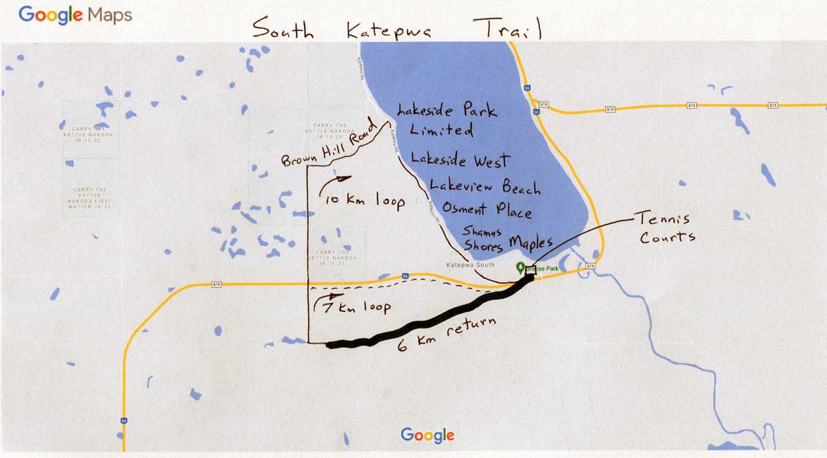
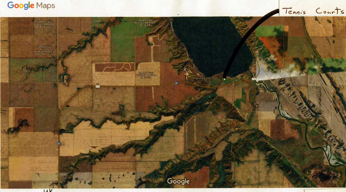
- Katepwa Ice Trail (formerly South Katepwa Trail) is the longest, provides a gentle grade, passes through forests, and has spectacular forest views. Once you reach the midpoint, and before the trail starts to steepen, you can rest at a beautiful forest rest stop only 120 meters off the trail at the creek bed. The length of the Katepwa Ice Trail is described below. It is located in the RM of Indian Head 156. Parking is across the highway at the off-leash dog park in Breese Park.
Cutout Coulee and Hillside Nature are foot traffic only, with some steep sections, and are signed and described on the map here: Interior of Katepwa Nature Trail Brochure.
Katepwa Ice trailhead is 150 m from the off-leash dog park but unfortunately requires crossing highway 56 to get there. The grade is gentle enough for those who cannot manage the steep terrain of Cutout Coulee and Hillside Nature. This makes it suitable for additional 4F modes such as mountain bikes and cross-country skiing as well as noisier non-4F (but still fun) modes like snowmobiles and ATV’s. This trail is part of the original Red River cart path from Winnipeg to Qu’Appelle that saw heavy use in the 1800’s before the railroad was built. The name refers to the use of the trail by settlers, prior to electricity being available, to take ice from the lake in the winter to use for food refrigeration in root cellars in the summer.
To hike to the top of the valley through the beautiful, forested coulee and return is 6 km (hiking time 1 1/2 to 3 hours). Take a break before the climb begins, at the rest stop, only 120 meters off trail, at the midpoint of the route in a spectacular forest next to the creek bed. From the top, it is also possible to continue west along the road allowance and north on the grid road at the top of the valley and return to the off-leash dog park, either east using highway 56 (7 km total loop) or north and northeast on Brown’s Hill road to Lakeside Park Limited and Lakeside West and then southeast along the lake through Lakeview Beach, Osment Place, Shamus Shores and Maples (10 km total loop). These three routes are shown here Katepwa Ice Trail. A satellite map is here: Katepwa Ice Trail Area – Satelite Image. Also, check our Facebook and Instagram.
Money to look after these trails only comes from the village budget by request on a project-by-project basis, you can overcome that by donating directly here. Keep in mind that our finances and activities are separate from those of the volunteers at the Trans Canada Trail. If you’d like to talk to someone about these trails, phone Rick Vigrass at 306-332-4859 (landline).
January 2025